
[RE]ESPRTK NTRIP Caster Server Base F9P Ardusimple ESP32 WIFI Ethernet DDNS AGOPENGPS RTK
AgOpenGPS
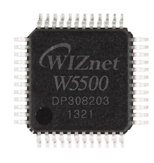
WIZnet - W5500
x 1
hello
Today I'm going to introduce the UX of using the W5500 for the AgOpenGPS project.
First, AgOpenGPS is an open-source automated farm management program.
In Korea, automated farming is usually limited to controlling temperature and humidity in greenhouses and watering crops, but AgOpenGPS is a project that originated in Canada, which has a large farmland, so to manage that farmland, tractors can be controlled in real-time based on GPS data and scanned based on a learned map.
Translated with DeepL.com (free version)
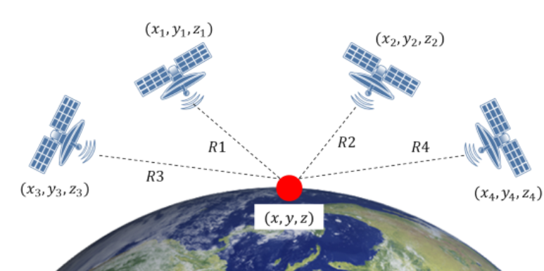
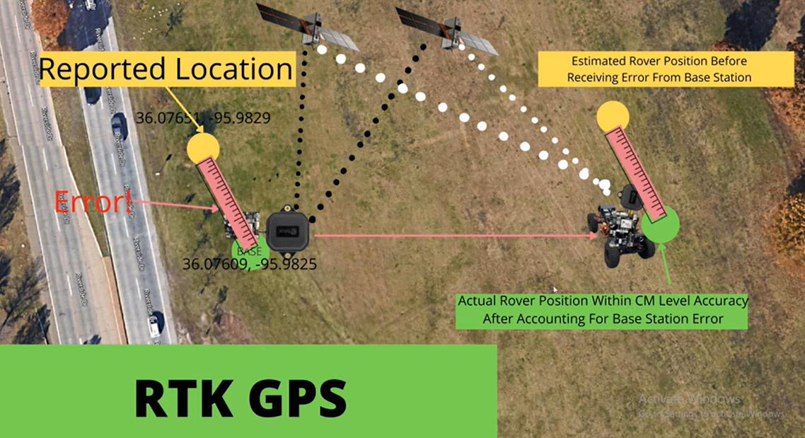
GPS as we know it has an error of as little as 5 meters and as much as 10 meters.
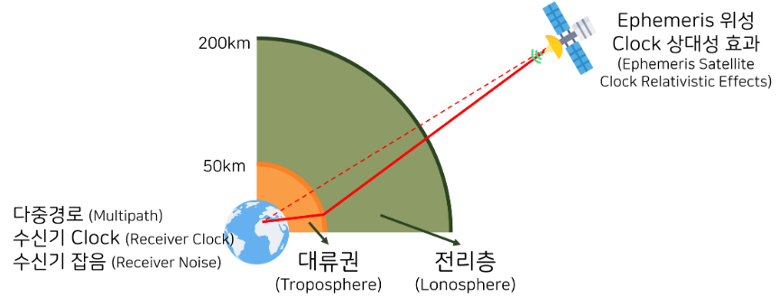
This is due to noise and time delays in the troposphere and ionosphere.
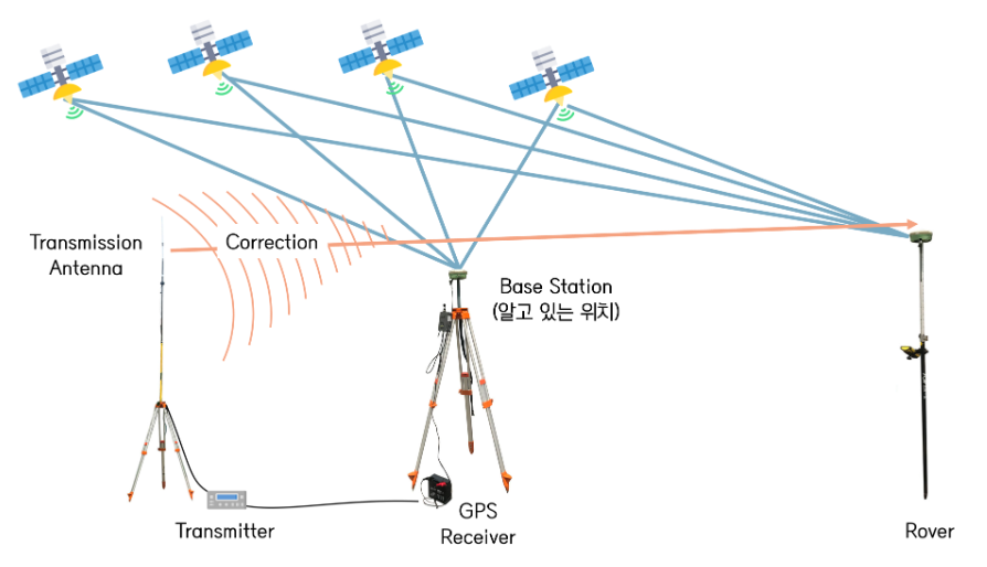
However, a calibration method called RTK GPS can reduce the error to within a few centimeters by transmitting the measured error from a base station with an accurate satellite reference point to the device (Rover).
In simple terms, if your base station's satellite reference is (30,30) and your GPS reads (30,29), you can tell a nearby device that its y-coordinate is -1 due to signal distortion from the troposphere and ionosphere, and that device will compensate for the -1 on the y-axis in the coordinates it reads from its own GPS.
Naturally, RTK GPS requires that the base station knows the exact satellite reference point and is as close as possible to the device you are measuring.

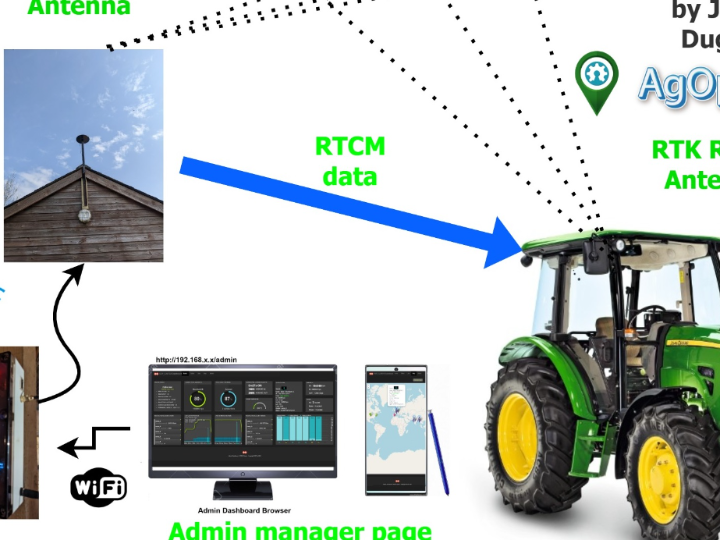
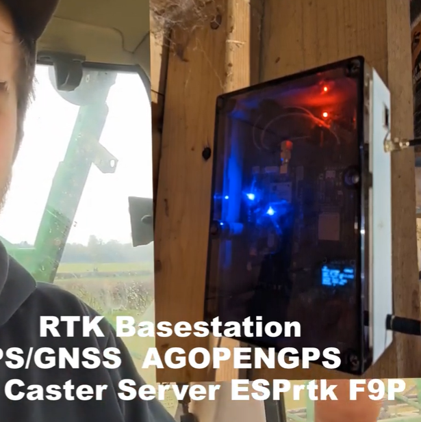
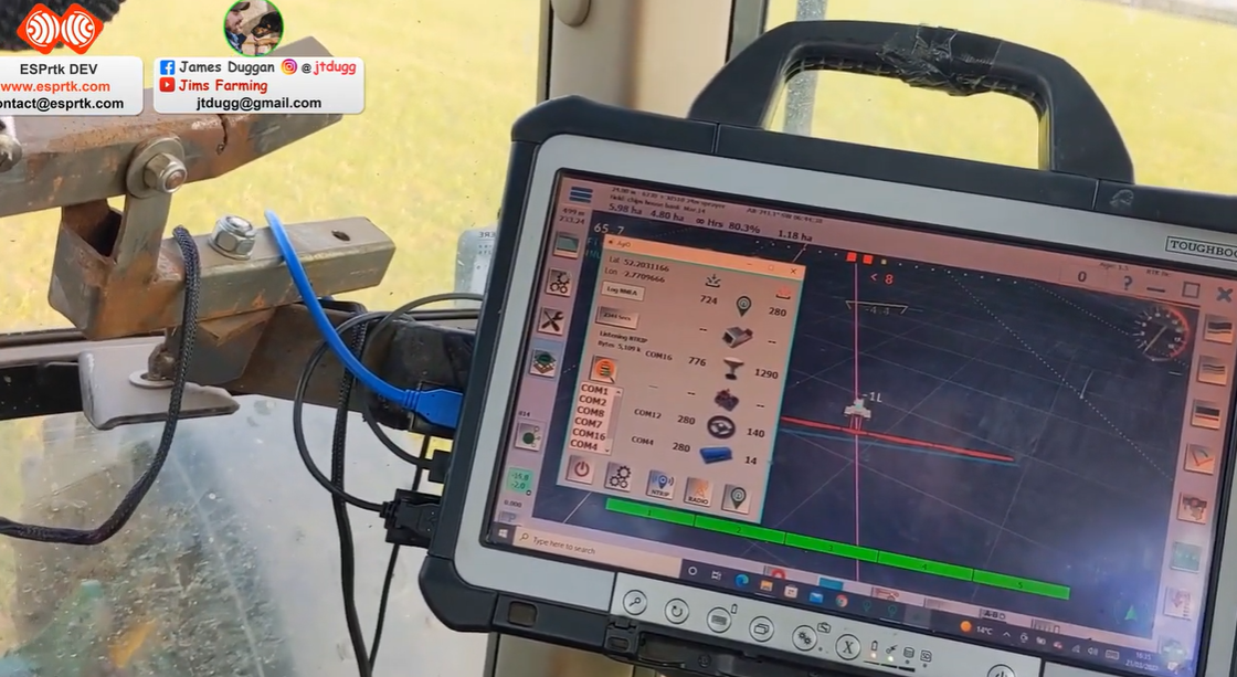
Using this RTK GPS positioning method, the author of the article, James Duggan, used the W5500 to configure his base station. In the video of the actual run, he only used WiFi, but he recommends in the text that you use an ethernet connection rather than WiFi for full 24/7 operation.
Inside the tractor, you must have a tablet PC with a Window OS that AgOpenGPS can run on and a
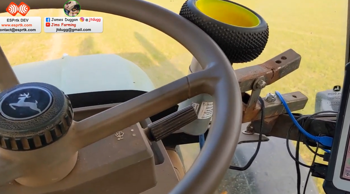
make gears to control the steering wheel so that you can turn the steering wheel, or you can use rubber wheels like the author did.
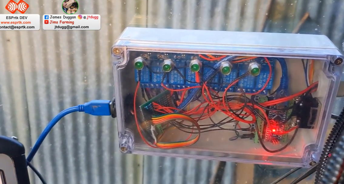
In addition, a number of other devices are installed to control the tractor's sprayers.
The project to automatically control tractors on a farm using RTK GPS was very interesting because it is extremely rare in Korea.
안녕하세요
오늘은 AgOpenGPS 프로젝트에 W5500을 사용한 UX를 소개하겠습니다.
먼저 AgOpenGPS란, 오픈소스의 자동화 농장 관리 프로그램입니다.
대한민국에서 자동화 농장 하면 보통 온실의 온습도 제어 및 농작물에 물을 공급하는 정도가 되겠으나 AgOpenGPS는 광활한 농지를 사용하는 캐나다에서 시작된 프로젝트인 만큼 그 거대한 농지를 관리하기 위해 트랙터를 GPS 데이터를 기반으로 실시간 제어 및 학습시킨 지도를 기반으로 스캐줄 운행을 가능하게 합니다.
우리가 흔히 아는 GPS는 오차가 적게는 5M 크게는 10M 정도 나기도 합니다.
이는 대류권과 전리층에서 잡음 및 시간 지연 등의 이유로 오차가 발생하게 됩니다.
하지만 RTK GPS라는 보정 방법은 정확한 위성기준점을 갖고 있는 Base Station에서 측정된 오차값을 장치(Rover)에 전송하여 오차를 수cm내로 줄일 수 있습니다.
간단하게 말하면 Base Station의 위성기준점이 (30,30)인데 GPS로 측정한 좌표가 (30,29)라면 대류권, 전리층에서 발생한 신호 왜곡으로 인해 Y좌표가 -1이 되었다는 사실을 근처의 장치에게 전달하면 그 장치는 본인이 탑재한 GPS에서 읽은 좌표에 Y 축으로 -1을 보정하게 됩니다.
당연하게도 RTK GPS는 Base Station이 정확한 위성 기준점을 알고 있어야 하고, 측정하려는 장치와 최대한 가까워야 합니다.
이러한 RTK GPS 측위 방식을 사용하여 해당 글의 저자인 James Duggan은 Base station을 구성하는데 W5500을 사용하였습니다. 실제 구동 영상을 보면 WiFi만 사용했지만, 그는 본문에 24시간 풀 가동하기 위해서는 wifi보다는 ethernet 연결을 사용하는 것을 추천했습니다.
트랙터 내부에는 AgOpenGPS가 돌아갈 수 있는 Window OS가 설치된 타블렛 PC가 있어야 하고
스티어링 휠을 돌릴 수 있게 스티어링 휠 제어용 기어를 만들거나 저자처럼 고무 바퀴를 사용해서 제어할 수 있습니다.
이외에 트랙터의 분사 장치를 컨드롤 할 수 있게 여러가지 장치들이 설치됩니다.
RTK GPS를 사용하여 농장에 트랙터를 자동제어 하는 프로젝트는 국내에서는 극히 드문 프로젝트라서 굉장히 흥미로웠습니다.